Section Menu:
Building & Zoning
Building FAQs
To obtain a building or development permit in the Rural Municipality of Reynolds, you must complete the application process and pay the fees established in the municipal fee schedule.
The Application Process
According to the Zoning Bylaw, you must follow these steps before starting any construction, excavation, or change of use:
Submit an Application: Applications must be made to the Development Officer or a designated employee.
Provide Plans: You must include hardcopy drawings, to scale, and structural drawings must be sealed by a structural engineer.
Ensure Compliance: The proposal must comply with all requirements of the Zoning Bylaw, as well as applicable provincial and national building codes.
Wait for Issuance: Construction cannot begin until a permit is officially issued.
Permit Costs (Fee Schedule)
The cost of your permit depends on the type and size of the project. See the Building Permit Fee Schedule A – By-Law 14-2020 for a complete list of permit fees.
Important Financial Rules to Keep in Mind
Minimum Fee: There is a minimum permit fee of $75.00.
Penalty for Starting Without a Permit: If you begin construction before a permit is issued, you will be charged twice the normal permit fee (or up to four times, as determined by Council).
Refunds: If you request a refund in writing, it is subject to a 25% or a minimum of $35.00 administration fee. No refunds are given if a permit is revoked.
To obtain a permit to install a septic field or system in the RM of Reynolds, you must coordinate between the provincial environmental authority and the municipal building office.
Provincial Registration (The Primary Permit)
The municipality does not issue the permit for the septic system itself. You must apply to the province to ensure the system meets environmental and health standards.
- Authority: Manitoba Environment and Climate Change.
- Required Action: You must submit an “Application to Register an Onsite Wastewater Management System” before any work begins.
- Contact: Justin Paille
- Ph: 204-392-4020
- Email: justin.paille@gov.mb.ca
- Documentation: You will typically need to provide a site plan showing distances from your well and property lines, as well as soil information (such as a soil texture analysis).
- Inspections: A provincial Environment Officer must authorize the installation. Crucially, you cannot cover the system with backfill until it has been inspected and you receive an “Authorization to Cover”.
Local Plumbing Permit
While the province regulates the field and tank, the RM of Reynolds regulates the plumbing that connects your dwelling to that system.
Authority: RM of Reynolds Municipal Office (204-426-5305).
Required Action: You must apply for a Plumbing Permit for the internal drain and vent system.
Zoning Setbacks
The Zoning Bylaw dictates where on your property the system can be placed.
A minimum floor area of 600 sq. ft. is required for a dwelling.
To apply for a new driveway in the Rural Municipality of Reynolds, you must follow the procedures outlined in Policy No. 03 (Driveway & Culvert Policy) and ensure the design meets the standards set in the Zoning Bylaw.
The Application Process
According to Policy No. 03, you cannot excavate or construct a private approach without prior authorization.
Step 1: Obtain the Application Form: Use the “Culvert/Approach Application” (found as Schedule A in the above Policy No. 03 document).
Step 2: Provide Property Details: You must provide the legal description (Section, Township, Range, Lot/Block/Plan) and the civic address.
Step 3: Sketch & Map: You are required to attach a sketch showing the location of the requested driveway relative to property corners, along with a “Google Photo” or clear map.
Step 4: Specify the Use: Indicate if the driveway is for Agricultural, Residential, or Commercial use.
Step 5: Submission: Submit the completed form to the municipal office in Hadashville for inspection.
When you submit a Building/Development Permit application, the Municipality requires your site plans and construction drawings to be “to scale”.
In simple terms, a scaled drawing is a mathematically accurate miniature of your project. It ensures that the proportions on your paper match the real-world dimensions of your land and buildings exactly.
Common Scales
You don’t need professional drafting software to create a scaled drawing, but you must use a consistent ratio and a ruler. Here are the two most common methods:
For Site Plans (The Big Picture):
1 inch = 20 feet: This is used to show your entire “parcel of land”. Every inch you draw on the paper represents 20 feet of your actual yard. This helps officials see how the project fits within your property boundaries.
For Construction Drawings (The Details):
1/4 inch = 1 foot: This is used for “incidental alterations” or building details. Every quarter-inch on the paper represents one foot of the actual structure. This is how you show where windows, doors, and interior partitions will be located.
Tip: Use graph paper to make this easy. Assign a value to each square (for example, 1 square = 2 feet). As long as you stay consistent throughout the entire drawing, your plan will be “to scale.”
Determining how far a building must be from a roadway, property line, or river involves consulting both the specific Bulk Requirement Tables and the General Provisions found in the RM of Reynolds Zoning Bylaw (2014).
Identify Your Zoning District
Before looking at a table, you must know your “Zone” (e.g., GD, RSR, RM1). You can find this by looking at the Zoning Maps at the end of the Bylaw or by contacting the RM office.
Consult the “Use and Bulk Requirement” Tables
The Bylaw uses specific tables to list the minimum “yards” (setbacks). A “Yard” is the open space required between a building and a property line.
Front Yard: Distance from the front property line.
Side Yard: Distance from the side property boundaries.
Rear Yard: Distance from the back property boundary.
Key Tables to Reference:
Table 4.1: “GD” General Development Zone — This is where the 75-foot front yard requirement for dwellings is found.
Table 4.3: “RSR” Rural Settlement Residential — Check here for smaller residential lots, which may have different requirements.
Table 4.6: Rural Zones (RGZ, RM1, RM2) — Use this for larger rural or agricultural parcels.
Setbacks from Rivers and Water (Hazard Lands)
Distances from a river are not usually found in the Bulk Tables. Instead, you must look at Section 3.12 (Hazard Lands).
The Rule: Buildings must be set back from the Ordinary High Water Mark of any natural water body (rivers, streams, or creeks).
Environmental Protection: These setbacks are designed to prevent erosion and protect the building from flooding. While the Bylaw defers to provincial experts for exact distances, a standard environmental buffer is often 30 metres (approx. 98 feet).
Special Provisions to Watch For
Beyond the tables, there are “Special Provisions” in Part III that might change your required distance:
Corner Lots (Section 3.17.3): No buildings or high fences are allowed within a 30-foot “Clear View Triangle” at the intersection of two streets to ensure traffic safety.
Accessory Buildings (Section 3.1): While sheds and garages generally follow the same front yard rules (e.g., 75 feet in the GD zone), they must also be at least 10 feet away from the main house.
Provincial Roads (Section 3.27): If your property borders a Provincial Trunk Highway (PTH) or Provincial Road (PR), the province may require a much larger setback than the RM does. You may need a separate permit from Manitoba Infrastructure.
Zoning FAQs
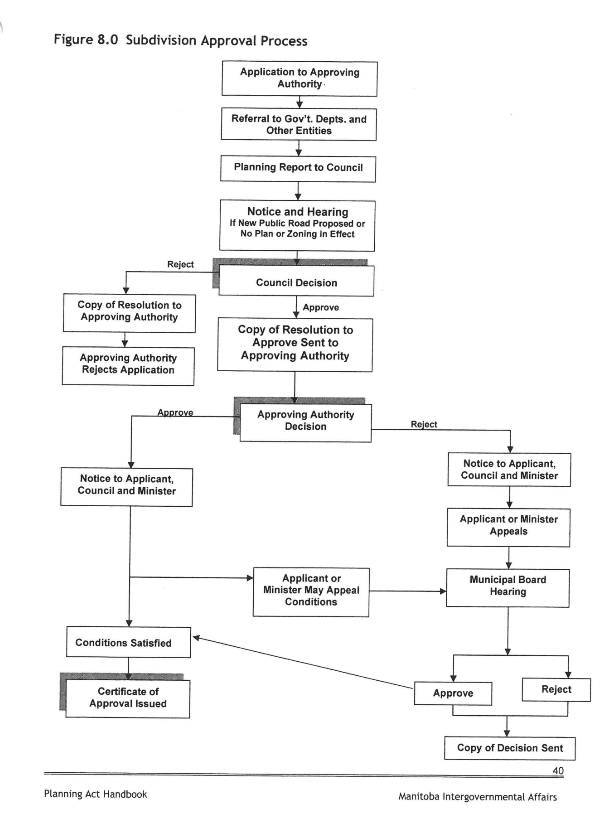
To subdivide property in the Rural Municipality of Reynolds, you must navigate a multi-stage process involving the local Planning Office, the Municipal Council, and various provincial agencies.
The process can take anywhere from 12 – 18 months.
Here is a brief step-by-step process and the associated costs:
Initial Application and Planning Phase
The process is best started by contacting the Planning Office in Beausejour (204-268-6058).
Eligibility: Only the registered owner(s) of the land may apply for a subdivision.
Survey Requirement: You are responsible for providing a S.A.M. (Survey Application Map) at your own cost.
Submission: The formal application is submitted to the Approving Authority.
Agency Referrals and Planning Report
Once the application is received, the Planning Office coordinates with external entities:
Government Referrals: The application is sent to agencies such as Manitoba Infrastructure, Manitoba Hydro, MTS, and Manitoba Agriculture for their input and to identify any concerns.
Environmental Approval: If the subdivision involves septic fields or tanks, these must be approved through Manitoba Environment.
Planning Report: A comprehensive planning report is then prepared and submitted to the RM Council.
Municipal Council Review
The Council evaluates the proposal against the local Development Plan and Zoning Bylaw:
Public Hearing: A notice and public hearing are required if a new public road is proposed or if there is no existing plan or zoning in effect for the area.
Zoning Compliance: New lots must meet “Bulk Requirements,” such as the 2-acre minimum site area and 200-foot site width required in the General Development (GD) zone.
Council Decision: Council will issue a resolution to either Approve or Reject the application.
Final Approval and Conditions
If Council approves, the application returns to the Approving Authority for a final decision.
Development Agreement: You will likely be required to sign a Development Agreement and register a Caveat for that agreement at your own cost.
Satisfying Conditions: All conditions set by the Council or Approving Authority (such as road improvements or utility easements) must be satisfied.
Certification: Once all conditions are met, a Certificate of Approval is issued, and the subdivision is finalized.
Estimated Costs and Fees
The following fees apply per the website and municipal schedules (subject to change by Council resolution):
Administration Fees:
RM of Reynolds Administration Fee: $100.00.
Planning Administration Fee: $550.00.
Lot Dedication Fees:
RM of Reynolds Lot Dedication: $700.00 per lot created.
Planning Lot Dedication: $300.00 per lot created.
Additional Costs: You are responsible for all legal fees, S.A.M. survey costs, and costs associated with the Development Agreement and Caveat registration.
Residents can legally have 2 household pets in the RM of Reynolds. No licenses are required.
To determine your zone and whether you are permitted to have chickens, you must consult the following sections of the Rural Municipality of Reynolds Zoning Bylaw:
How to Find Your Zone
To identify which zone your property falls under, you must refer to the Zoning Map.
The Zoning Map: The municipality is divided into specific zones as shown on “Map 1 RM of Reynolds Zoning Map”.
Zone Categories: The Bylaw establishes several types of zones, including:
Urban – Residential Zones.
Rural Zones (e.g., “RGZ”, “RM1”, “RM1c”, and “RM2”).
Commercial/Industrial Zones.
If your property is near a boundary, the Bylaw provides specific rules for the “Interpretation of Zone Boundaries” to clarify exactly which regulations apply to your site.
Permissions for Chickens
The Bylaw regulates chickens under three primary categories, depending on the scale of the operation:
A. Livestock Operations (Large Scale) If you intend to keep a significant number of chickens for profit or large-scale production, it is classified as a Livestock Operation.
Definition: A livestock operation involves an “animal housing facility” or “confined livestock area”.
Animal Units: The Bylaw measures the scale of these operations using “Animal Units” (a.u.). You must refer to Table 4.9: Animal Unit Summary Table to determine how many chickens constitute a specific number of animal units.
Requirements: Livestock operations are subject to “Minimum Mutual Setback Requirements” (Table 4.8) and “Conditional Use Guidelines”.
B. Agricultural Activity (Small/General Scale) For non-commercial or general agricultural purposes, chickens may fall under Agricultural Activity:
Definition: This includes the production of agricultural products and the “pasturage” of animals.
Exclusions: This category specifically does not include “livestock operations” as defined above.
C. Under Residential Related Farm, chickens are allowed to a maximum of 9.9 AU or 1 AU per acre, whichever is less. This requires a Conditional Use Order from the municipality.
Summary Recommendation: First, locate your property on the Zoning Map. Once you know your zone, you must check the corresponding Use and Bulk Requirements Table (e.g., Table 4.1 for General Development or Table 4.6 for Rural Zones) to see if “Agricultural Activity” or “Livestock Operations” are listed as Permitted or Conditional uses in that specific area.
An Animal Unit (a.u.) is a standard measurement used by the municipality to determine the environmental impact of livestock on a piece of land.
Instead of counting every individual animal, the municipality uses this unit to “level the playing field” between different types of livestock based on how much nitrogen they produce in a year.
Understanding the Concept
Think of an “Animal Unit” like a “budget” for your land.
Large animals (like a dairy cow) use up a large portion of that budget.
Small animals (like chickens) use up a very tiny portion.
The Goal: The total “Animal Units” on your property must stay within the limit allowed for your specific zone to protect the soil and water.
How to Calculate Your Animals
Step A: Identify your Zone
First, find your property on the Zoning Map. This indicates whether you are in a Rural (RGZ, RM1, RM2), Residential (RSR), or General Development (GD) zone.
Step B: Find your “Budget” (Animal Unit Limit)
Look at the Use and Bulk Requirements Table for your specific zone.
For example, in Rural Zones (Table 4.6), the Bylaw specifies how many Animal Units are allowed as a “Permitted” use versus a “Conditional” use (which requires special Council approval).
Some zones may have a limit of “0” animal units for certain types of operations.
Step C: Convert Animals to Units using the Summary Table
The Bylaw includes Table 4.9: Animal Unit Summary Table. This table lists the “Animal Unit” value for different livestock. You multiply the number of animals you want by the factor in the table.
Example Calculation (Using typical values)
If the table states that 1.0 Animal Unit is equal to 200 laying hens:
If your zone allows for 2.0 Animal Units, you could have up to 400 hens ($2.0 times 200 = 400$).
If you only want 20 hens, you would only be using 0.1 Animal Units ($20 / 200 = 0.1$), which is likely well within the limit for most rural areas.
Below is the Animal Units Simplified for your convenience:
Important Restrictions
Livestock Operations: If your total animal units exceed a certain threshold (often 10 a.u. or more, depending on the zone), you are classified as a “Livestock Operation” and must follow much stricter rules regarding how far your barns must be from your neighbour’s house.
Nitrogen Limit: The entire system is based on the rule that 1 Animal Unit equals 73.00 kg (160.93 lb.) of nitrogen produced per year. This ensures the land can safely handle the manure produced.
